Showing posts with label uk. Show all posts

Wednesday, 15 November 2017

Nine Mile Point

Nine Mile Point


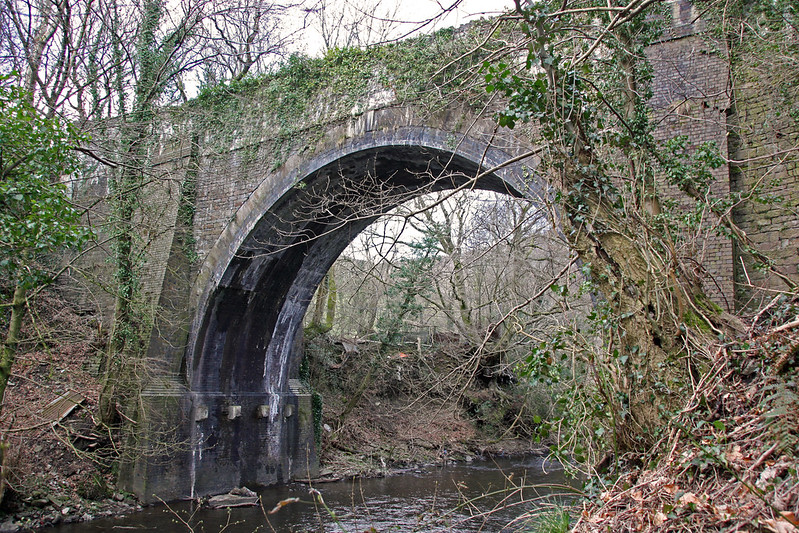
This early tramroad bridge at Nine Mile Point was constructed in 1824 to carry Penllwyn Tramroad over the Sirhowy River to it's junction with the Sirhowy Tramroad. The Sirhowy Tramroad had obtained the third Act of Parliament in Britain for a railway in 1806 and had built their tramroad down the opposite side of the valley to this point. From here to Newport the tramroad was built by the Monmouthshire Canal Co, whose own Act allowed compulsory purchase of land to built feeder tramroads of up to eight miles. The 'missing' mile was owned by Lord Tredegar who built and maintained the 'Park Mile' where the line crossed his estate, and extracted a lucrative toll for the priviledge until finally bought out by the GWR many years later.

Following conversion to an edge railway in the 1860s, the Monmouthshire Railway & Canal Co section of the Sirhowy line was sold to the GWR. The Sirhowy Railway was expected to follow suit, but upon receipt of a lower than expected offer from Swindon in 1876 the Sirhowy Railway sold their line to the LNWR instead, who were only too pleased to gain a foothold in the valleys. Nine Mile Point therefore became a remote end-on junction between the LNWR (later LMS) and the GWR until Nationalisation.

The lower two miles of the Penllwyn tramroad to Ynysddu was vested in the Sirhowy tramroad on completion, and the line continued as the privately owned Llanarth tramroad as far as Blackwood. Horse drawn traffic on the line is thought to have continued until the 1860s, and from 1887 to the early 1900s a wagon was passed over the line once a year to maintain the right of way.

In 1902 the sinking of Nine Mile Point colliery began near Cwmfelinfach and the bottom end of the Penllwyn tramroad was relaid and brought back into use for access; the brick reinforcing of the bridge is assumed to date from this period. Initially coal was exported over the tramroad link but as part of the development a new double track bridge was built slightly further north and opened in 1908. In 1905 the Penllwyn line was further relaid up the valley to Ynysddu and goods depots provided at Ynysddu, Cwmfelinfach and Wattsville (passengers being carried by the Sirhowy line on the opposite side of the valley).
2013 04 16 01 nine mile point 070a
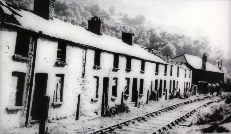
The Penllwyn tramroad through Cwmfelinfach past Babell Chapel and Babell Row in the 1920s. Many of the industrial revolution-era settlements in the valley were built along the tramroads.
In 1914 the line across the tramroad bridge was no longer required and was lifted, Wattsville goods being accessed by back-shunting from Nine Mile Point colliery thereafter. From then on the bridge was used as pedestrian access from Wattsville to the station at Nine Mile Point, there being no other access except for the ancient road which fords the river below the bridge. Twenty years ago I can remember a line of old lamposts still crossing an open field towards the bridge from the houses at Brynawel on the valley road!

gwr nine mile point 1915c crop
Nine Mile Point in 1915 (Ordnance Survey)
When my father first took me to see the bridge as a young child it was in a very sorry state, with one parapet missing completely and the other with large holes. A double line of GWR spear railings constrained a narrow footpath to the centre of the span. Fortunately the bridge received Grade II listing in 1999 and has recently been restored by the local council.


Sources and Further Reading
Railways in the Sirhowy valley - W.W. Tasker, 1992  Amazon
The Brecon Forest Tramroads: the archaeology of an early railway system
 - Stephen Hughes, 1990 Amazon
http://www.industrialgwent.co.uk/c11-sirhowys/index.htm
https://www.flickr.com/photos/cymro76/8727310977/
National Library of Scotland OS 6inch:1mile map of Nine Mile Point, 1898

Tuesday, 31 October 2017

The Sea Lock Pound, 1891

The Glamorganshire Canal met the Bristol Channel, and the rest of the world, at the very southern edge of Cardiff where an enlarged section of canal called the Sea Lock Pound was built to accommodate sea-going vessels. Pig iron from Merthyr was transferred to the larger vessels here to continue its journey, access to the Severn Estuary being obtained via a large lock allowing entry and exit at high tide.

This was the oldest section of 'The Docks' and when the industrial focus of the South Wales valleys shifted from iron to coal it quickly became  too small and increasingly larger docks were constructed either side. The old Sea Lock Pound was home to numerous maritime services and small industrial premises along with workers housing and pubs and even hosted the Bute United Rowing Club for a few years in the late 1880s. After the railways took the majority of traffic away from the canal the canal company opened a private railway along the length of the pound in 1899 to connect the businesses with the GWR across Dumballs Road.

Following a long decline traffic ceased on the main canal closed in 1942 due to a breach at Nantgarw  and the entire undertaking was bought by Cardiff Corporation in 1944; the resale value of the land occupied by the canal as it threaded its way through the city centre had not gone unnoticed! Both the Sea Lock Pound and the adjacent Glamorganshire Canal Railway continued to operate though to serve the remaining businesses along this stretch.


The Sea Lock Pound came to an impressive end in December 1951 when the sand dredger Catherine Ethel accidentally hit the inner Sea Lock gates which promptly collapsed. The unfortunate ship was carried out into the estuary on a tidal wave as the whole of the mile long section of canal emptied itself. After the breach the Corporation began infilling the muddy ditch with refuse to create the linear park that survives today. The Glamorganshire Canal Railway continued to operate amongst the dereliction but as the old businesses moved away or closed down traffic dwindled and the line was closed by the Corporation in 1963.


The Sea Lock Pound in 1921


Sources and Further Reading
https://en.wikipedia.org/wiki/Glamorganshire_Canal
https://www.peoplescollection.wales/items/11626 
https://www.peoplescollection.wales/items/11627
https://www.peoplescollection.wales/items/11628
https://www.peoplescollection.wales/items/27609 
The Glamorganshire and Aberdare Canals (Vol.1), Stephen Rowson & Ian L. Wright - Black Dwarf Publications, 2001 Amazon
The Glamorganshire and Aberdare Canals (Vol.2), Stephen Rowson & Ian L. Wright - Black Dwarf Publications, 2004 Amazon
A South Wales Canal and its Railway, Ian L. Wright - Railway Magazine, October 1965

Sunday, 29 October 2017

Iona, 1st September 1856

Iona

Welcome

I often find evocative gems like this on my wanders through the internet. They send me searching to the corners of the web for everything I can find about the topic, sometimes for an evening, sometimes for a few weeks, before something equally interesting catches my eye and I move onto the next thing. Rather than let the knowledge I've gathered get pushed to the corners of my mind and eventually get forgotten, I though I would set it down here and share it. Expect posts on railways, canals, industry and architecture with some of my own photos of historic places that have managed to survive into the modern world.

This picture from the dawn of photographyseems like a good place to start the journey. Taken by Thomas Keith on 1st September 1856, it shows the ruins of the monastery of St Columba on the Inner Hebridean island of Iona.

"Thomas Keith took his pictures before seven in the morning and after four in the afternoon to achieve the raking light, which picked out architectural detail and emphasised the structure of a building, as shown in this photograph of Iona Abbey. When Keith exhibited the picture in December 1856, a critic hailed it as 'a vigorous and most powerful picture'. The figure is probably Keith's wife, Elizabeth Johnston, whose presence offers us a nineteenth-century meditation on the ancient Christian ruins of the abbey, founded by St Columba in the sixth century."

Interestingly, not only have the ruins survived but the monastery was actually rebuilt in the early 20th Century and is now home to an ecumenical community.
 

Sources and further reading:
https://www.nationalgalleries.org/art-and-artists/10329/iona
https://en.wikipedia.org/wiki/Iona_Abbey
https://iona.org.uk/island-centres/the-abbey/